VILLABANDÍN ALTO LA CAÑADA ROUTE
PWe leave the village of Villabandín and take a path that goes along the left bank of the river Oceo. A few metres after taking this path, we leave it and take a barely visible path that zigzags and heads towards the Estiliello stream. At one point, this path ends and we leave it to the right to continue through the mountains until we reach a gap in the stream. At this point we turn left and start to climb along the edge of this gap between large pines.
We go up until we find a clearing and a path that enters the valley until we reach the stream. We go up the stream until we find a path that goes up to the right hill, towards the Chano del Estupiello. Before reaching it, we leave the path to the left to continue along the hill and take a path that takes us to Braña Llampa.
Here we go up the first stream we come across on the right, along a path that is easy to follow, and which takes us to one of the ridges that goes down from Vidulina. We go up this ridge and before reaching the summit of La Vidulina, we turn off slightly and continue towards the Alto de La Cañada following the ridge.
From here, the route continues to Rabinalto, Peña de la Arena, with its two summits and Valgrán. We then head towards Los Concichones and the Villabandín pass, where the path gets lost at times.
From the pass we descend to the left to the bottom of the valley until we join the path that takes us back to Villabandín, passing by a spring that emerges from under a rock with a sign that says «Fuentes Blancas» (White Springs).
MUNICIPALITY
Murias de Paredes
TYPE OF PATH
Pedestrian and cycle touring (MTB) some sections
COORDINATES
Start and finish: 42° 51′ 33″ N, 6° 8′ 14″ W
TECHNICAL DATA
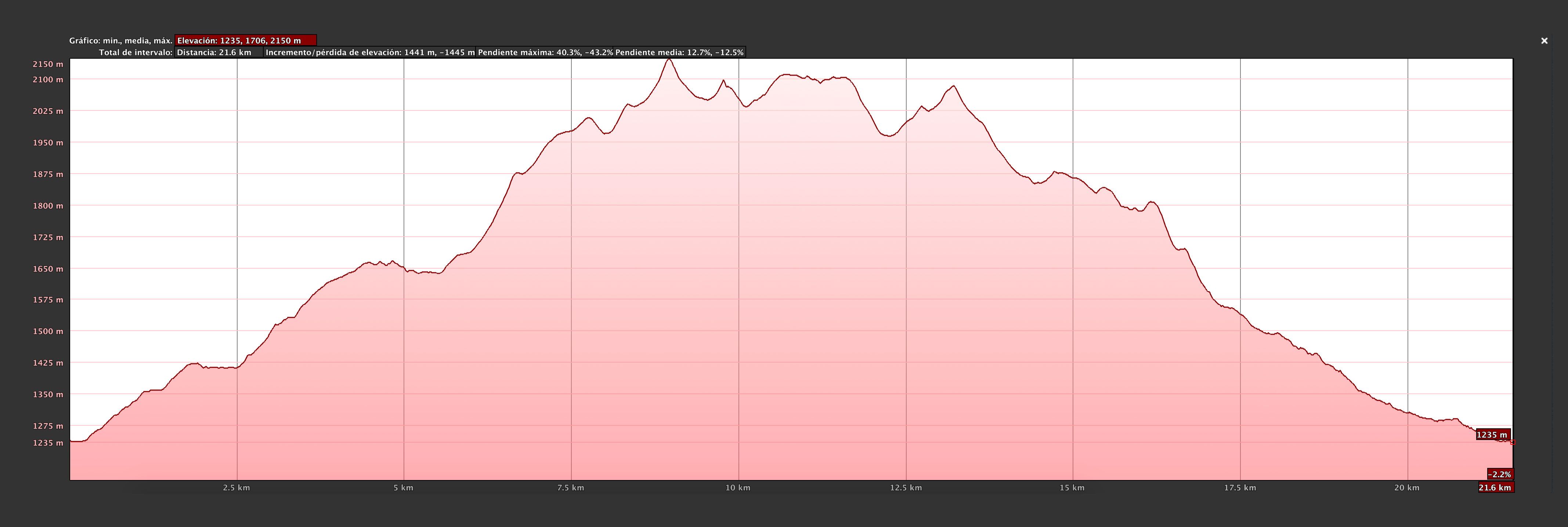
Approximate duration: 9 h 20 min
Distance: 21’6 km
Type of route: Circular
Difficulty: Medium
Difference in altitude ascent: 1.441 m
Altitude downhill: 1.445 m
Maximum altitude: 2.150 m
Minimum altitude: 1.235 m
DOWNLOAD THE ROUTE
Click on the different versions and download the route directly to your gps device or smartphone – walk with all the info at your fingertips!


-

Ayuntamiento de Murias de Paredes Plaza del Ayuntamiento, 2 – C.P.: 24130 – MURIAS DE PAREDES (León – España)
Teléfono: 987 593 007 / 987 593 082 e-mail: info[@]sienteomana.com