LAZADO – ALTO DE LA CURISCADA
From Lazado, we cross the village and, after passing through a gate and a bridge over the Valdeyeguas stream, we continue along a good dirt track. We go up the valley of Vladeyeguas along the left bank of the stream, until it takes us away from its source.
We follow the valley where another stream descends, that of La Curiscada, always on its left bank.
We reach the Curiscada mountain range, where we continue ascending a slope until we enter a path surrounded by broom trees, here we will have reached the summit of the Alto de la Curiscada.
This route is to always follow the forest path to the Braña de la Curiscada and from here go up a direct path to the mountain range.
To return to Lazado we return along the same path.
MUNICIPALITY
Murias de Paredes
TYPE OF PATH
Pedestrian walkway with cycle touring sections (MTB)
TECHNICAL DATA
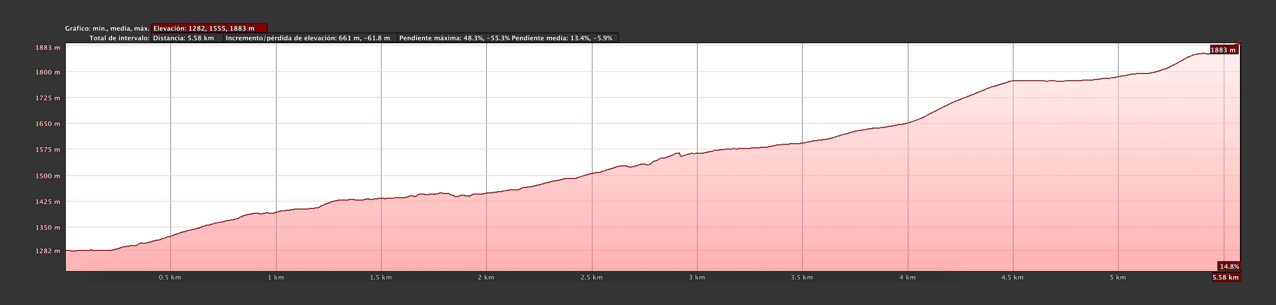
Approximate duration: 4 h 30 min (Return trip)
Distance: 11 km (Round trip)
Type of route: Linear
Difficulty: Medium
Elevation gain: 601 m
Maximum altitude: 1.883 m
Minimum altitude: 1.282 m
DESCARGA LA RUTA
Pincha en las diferentes versiones y descárgate la ruta, directamente a tu dispositivo gps o smartphone. ¡Camina con toda la info en tu mano!


-

Ayuntamiento de Murias de Paredes Plaza del Ayuntamiento, 2 – C.P.: 24130 – MURIAS DE PAREDES (León – España)
Teléfono: 987 593 007 / 987 593 082 e-mail: info[@]sienteomana.com